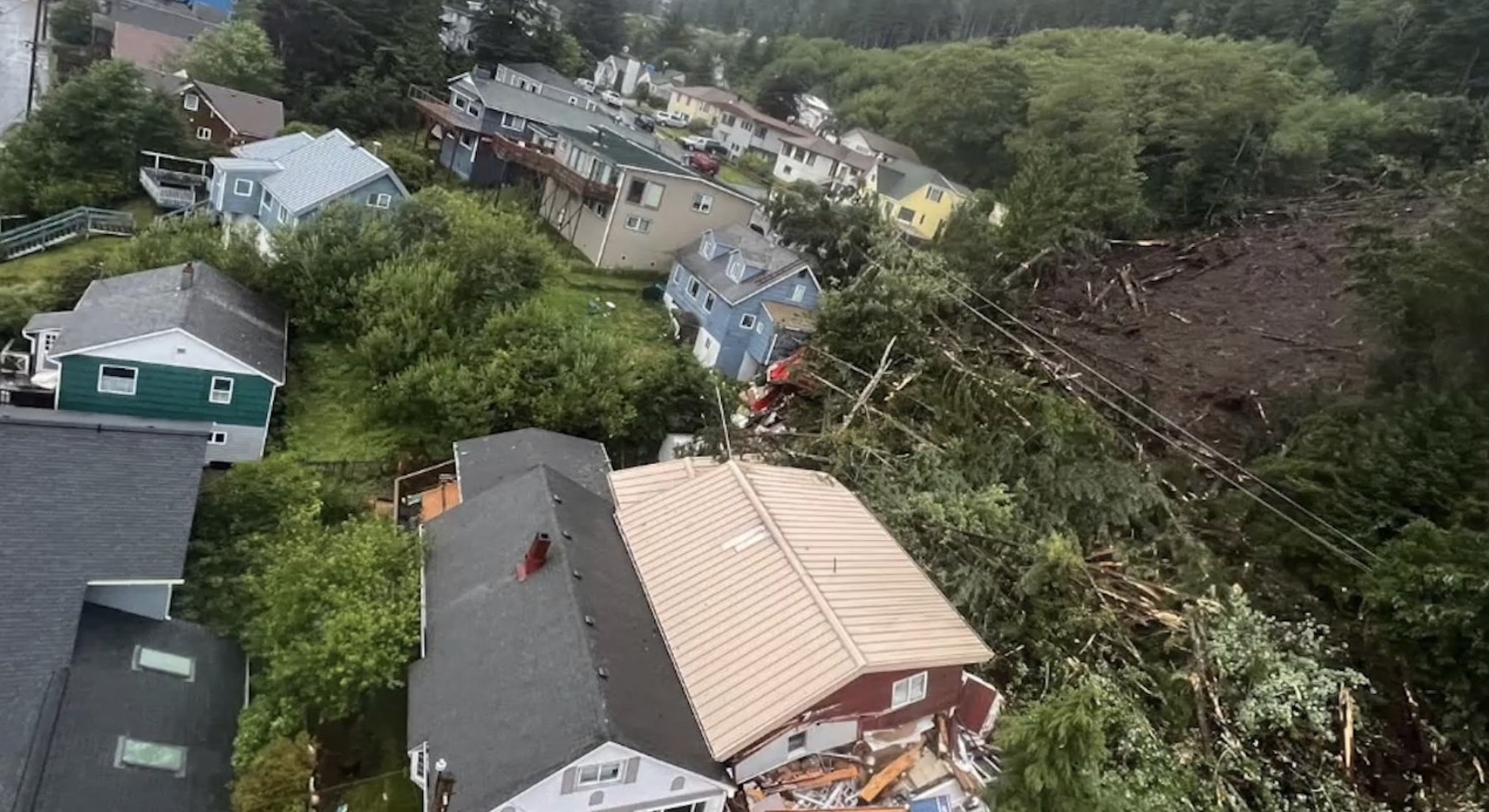
It happened on a Sunday. Usually, Sunday afternoons in Ketchikan are for catching up on chores or maybe grabbing a coffee before the work week resets. But August 25, 2024, wasn't a normal Sunday. Around 4:15 p.m., the ground just... gave up. A massive wall of mud, shattered Sitka spruce, and rocky debris tore down the mountainside above the Third Avenue Bypass.
Basically, the earth turned into liquid.
Ketchikan is used to rain. We’re talking about a place that measures annual rainfall in feet, not inches. But this was different. An atmospheric river had been dumping "unusually heavy" rain on the region for hours. The soil, already thin and sitting on steep bedrock, couldn't hold any more water. When that saturation point hits, gravity wins every single time.
The Human Cost of the 2024 Slide
Honestly, the numbers are hard to look at. One man died. Sean Griffin. He wasn’t just a statistic; he was a 42-year-old senior maintenance technician for the City of Ketchikan. He was actually out there in the storm, clearing drains to prevent flooding when the slide hit. It’s the kind of bitter irony that sticks in your throat.
Three others ended up in the hospital.
One was lucky enough to be treated and released quickly.
Two others stayed for a while.
Beyond the injuries, the landscape of the White Cliff neighborhood changed in an instant. Four homes were basically erased—critically damaged or destroyed. About 60 households had to pack bags and get out immediately. You've got people living in a coastal rainforest who are used to tough weather, but standing in a high school gym (Ketchikan High School was the emergency shelter) while your neighborhood is behind yellow tape is a different kind of reality.
Why Ketchikan Keeps Sliding
If you’ve ever walked the Rainbird Trail, you know how steep those hills are. Most of Ketchikan is built on a narrow strip of land between the Tongass Narrows and the mountains.
There's a geological reason for this mess.
Southeastern Alaska is a mess of metamorphic rocks—mostly schists and phyllites—covered in a very thin layer of "colluvial" soil and muskeg. When you get a massive dump of rain, that water gets trapped between the soil and the smooth bedrock. It acts like grease.
This wasn't an isolated fluke.
Mayor Dave Kiffer, who has lived in Ketchikan for over 65 years, said he’d never seen anything like it. But the data shows a scary trend. This was the fourth fatal landslide in Southeast Alaska in just ten years. Wrangell had one in 2023. Haines in 2020. Sitka in 2015.
Scientists are pointing toward climate change, and yeah, it’s not just a buzzword here. Warmer air holds more moisture. More moisture means these "atmospheric rivers" are becoming more like fire hoses. When that much water hits a steep, glaciated slope, the math is simple and deadly.
Recovery and the "New Normal"
The response was fast, I'll give them that. Governor Mike Dunleavy declared a disaster almost immediately. Within days, crews were clearing over 100 truckloads of debris. They even had to use drones for geological surveys because the slope was too unstable for people to hike up and check for "secondary" slides.
They had to build what’s called a "shoofly" bypass—a temporary road—to get traffic moving again.
But the "recovery" isn't just about paving over the mud. It’s about the people who can't sleep when it rains hard anymore. It’s about the fact that the Rainbird Trail, a local favorite, was partially chewed up. The city had to bring in experts from "Landslide Technologies" to figure out if the retaining walls on Third Avenue were even safe.
What Most People Get Wrong About Landslide Safety
You think you'll hear it coming. People say it sounds like a freight train.
Sometimes it does.
Sometimes it doesn't.
If you live in Southeast Alaska, or any mountainous coastal area, you've got to watch for the quiet signs.
- New cracks in your driveway? That’s a bad sign.
- Doors or windows that suddenly stick? The house might be shifting.
- "Drunken trees" (trees leaning at weird angles) are a huge red flag.
- If a nearby creek suddenly goes from clear to muddy, or stops flowing entirely, get out. It means there’s a blockage upstream that’s about to burst.
How to Actually Prepare for the Next One
You can’t stop a mountain from moving, but you can stop being in its way.
First, check the maps. The Alaska Division of Geological & Geophysical Surveys (DGGS) has been working hard to map these hazard zones. If you’re in a high-susceptibility area, you need a "Go Bag" that isn't just sitting in the back of a closet. You need it by the door.
Listen to the weather service. If they’re calling for an atmospheric river or "record-breaking precipitation," that’s your cue to maybe stay at a friend’s house on the flats.
Don't wait for the mandatory evacuation order.
By the time the sirens go off, the roads might already be blocked by a 1,100-foot-long river of mud.
Next Steps for Residents:
- Locate your property on the local landslide susceptibility maps provided by the Ketchikan Gateway Borough.
- Clear your culverts. Like Sean Griffin was doing, keeping water flowing where it’s supposed to go reduces the chance of soil saturation around your foundation.
- Register for Individual Assistance. If you were affected by the August slide, the State of Alaska’s Individual Assistance and Temporary Housing programs have specific windows for applications—don't miss the deadlines if you're still dealing with repairs.
- Sign up for Kbridge alerts. Get the local emergency management notifications sent directly to your phone so you aren't relying on Facebook for life-saving info.
The 2024 Ketchikan landslide was a wake-up call that the ground beneath us isn't as solid as we'd like to think. Staying informed is the only real defense we've got.